(4AM EST 7 January 1996)
Blizzard conditions developed
during the afternoon and evening as strong northeast winds developed around the intensifying low.

(5PM EST 7 January 1996)
There was a lull in the precipitation after midnight on the
8th for SE PA with the exception of Berks and the Lehigh Valley... where the snow continued non stop.

(5AM EST 08 January 1996)
wraparound snow returned during the daylight hours on the
8th...

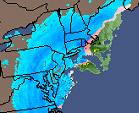
12PM EST 08 January 1996)
All-time single storm records were set at both the Lehigh
Valley International Airport (25.6 inches) and Philadelphia International Airport (30.7 inches). It should be noted the 30.7
inches represents a SNOWFALL ESTIMATE. Due to the considerable blowing and drifting of the snow, the observers at the airport
were forced to use a water equivalent/snowfall estimate table. The actual ACCUMULATION was probably less.

Snowfall accumulations averaged 20 to 22 inches in Monroe
and Carbon Counties, around 2 feet in Lehigh and Northampton Counties, 24 to 33 inches in Berks County, 20 to 26 inches in
Chester and Delaware Counties, 20 to 30 inches in Montgomery and Bucks Counties and 27 inches in Philadelphia. Other individual
accumulations included 33 inches in Ontelaunee Township (Berks), 30 inches in Reading (Berks) and Palm and Souderton (Montgomery),
28 inches in Perkasie (Bucks), 27 inches in Philadelphia (Franklin Institute) and 26 inches in Glenmoore (Chester).